We started hitch at Great Sand Dunes NP, working with Park Ranger Bill Stalker. We spent time cleaning the Nature Trail that leads to Mosca Pass Trail. That day we witnessed a dust storm, high winds, and spectacular dune hills spitting sand, swirling up above the ridges and disappearing into the air.
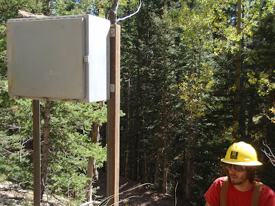
The following day Cory and went with Geologist Andrew Valdez to install hydrological telemetry equipment in the mountains. Before leaving he explained the parks air quality testing equipment, then collected the air filters to be sent off to UCLA for analysis. The equipment reads water flow in a creek, then sends the information at precisely the right time using GPS. Thus it eliminates the need for people like Andrew to drive deep into the mountains over several hours and risk getting stuck in sand or with a flat tire on rugged terrain.
Our last day at Sand Dunes, we worked through several hours of rain. It continued to rain, and by morning the Dunes had received more than 1/8 of their annual rain fall. We were offered shelter in the GSD Resource Management building and were grateful for the warmth and a kitchen and bathroom.
The following morning broke clear with sun and clouds climbing up into the high peaks from the low valleys and plains. We cleared fence posts from a historic settlement out near Crestone. By afternoon, we were leaving for Salida for further instructions. We were sent out behind Salida Mountain to maintain and renovate an "expert" level bike trail.
While moving a rockfor the construction of a rock wall to create a banked curve around a drop-off, I crushed the tip of my pointer finger. I was in the hospital with a doctor within 45 minutes.
 |
| The Great Sand Dunes |
 |
| I believe this is the Lophocampa Maculata caterpillar |
 |
| A great dust storm approaches |
 |
| Office of Andrew Valdez, Great Sand Dunes NP Geologist |
 |
| Air quality testing instruments |
 |
| Installing Hydrological Telemetry Equipment |
 |
| Walking back wet after a working a long rainy day |
 |
| On the road to Crestone |
 |
| Cabin designated as a historic building |
 |
| Starting on an embankment in the Salida Mountain Trails network |
 |
| Morning after my accident, smashing a finger under a rock |
 |
| I required some assistance the first few days |
 |
| Partial protection! |


